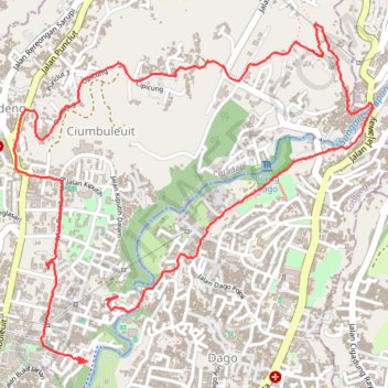
Boucle Ciumbuleuit Dago
Interactive map
GPS track profile
About this GPS track
Name: Boucle Ciumbuleuit Dago GPS track, route, trail
Start: Ciumbuleuit, Cidadap, Kota Bandung, Java occidental, Jawa, 40141, Indonésie (-6.87216 107.61034)
End: Ciumbuleuit, Cidadap, Kota Bandung, Java occidental, Jawa, 40141, Indonésie (-6.87527 107.60889)
Coordinates: -6.87538 107.60552 -6.85842 107.62355
Other GPS tracks
Click on a GPS track to view route, its statistics and profile.
Randonnée Boucle Cipaku
Indonésie > Java occidental > Kota Bandung > Isola
Randonnée pédestre. En aller simple. #Randonnée
Distance: 7.6 Km • Elevation gain: 251 m • Maximum elevation: 1,025 m
Rando parc Juanda
Indonésie > Java occidental > Kabupaten Bandung > Ciburial
Randonnée pédestre. En aller simple. #Randonnée
Distance: 7.3 Km • Elevation gain: 230 m • Maximum elevation: 976 m