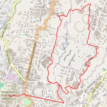
Randonnée Boucle Cipaku
Randonnée pédestre. En aller simple. #Randonnée
- Distance: 7.6 Km
- Elevation gain: 251 m
- Maximum elevation: 1,025 m
- Elevation loss: 279 m
- Minimum elevation: 881 m
- Moving time: 2 h 9 m
- Moving speed: 3.5 Km/h
- Maximum speed: 38.4 Km/h
- Total time: 2 h 22 m
- Global speed: 3.2 Km/h
- Date: 05/04/12
Interactive map
GPS track profile
About this GPS track
Name: Randonnée Boucle Cipaku GPS track, route, trail
End: Ledeng, Cidadap, Kota Bandung, Java occidental, Jawa, 40154, Indonésie (-6.85953 107.60093)
Coordinates: -6.86261 107.59193 -6.84482 107.60804
Other GPS tracks
Click on a GPS track to view route, its statistics and profile.
Rando parc Juanda
Indonésie > Java occidental > Kabupaten Bandung > Ciburial
Randonnée pédestre. En aller simple. #Randonnée
Distance: 7.3 Km • Elevation gain: 230 m • Maximum elevation: 976 m