Hebrideanway
- Distance: 322.3 Km
- Elevation gain: 4,198 m
- Maximum elevation: 268 m
- Elevation loss: 4,192 m
- Minimum elevation: 0 m
Interactive map
GPS track profile
About this GPS track
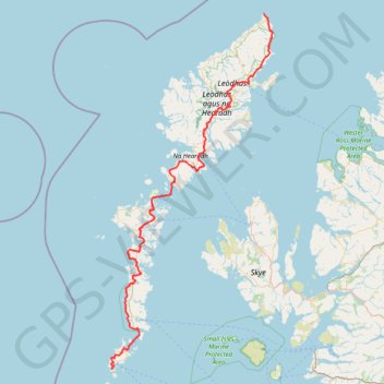
Name: Hebrideanway GPS track, route, trail
Start: Baile Bhatarsaigh, Na h-Eileanan Siar, Écosse, HS9 5YU, Royaume-Uni (56.91787 -7.53800)
Coordinates: 56.91787 -7.54340 58.51573 -6.18536
Other GPS tracks
Click on a GPS track to view route, its statistics and profile.
Skye Trail
Royaume-Uni > Écosse > Highland > Shulista
Distance: 127.4 Km • Elevation gain: 3,959 m • Maximum elevation: 655 m
Fairy Pools
Royaume-Uni > Écosse > Highland
Distance: 6.7 Km • Elevation gain: 236 m • Maximum elevation: 280 m
The Storr - ascent
Royaume-Uni > Écosse > Highland
GPX file from Walkhighlands; file is copyright Walkhighlands and must not be publicly shared on other websites. Do not remove this notice.
Distance: 7.9 Km • Elevation gain: 569 m • Maximum elevation: 708 m