100 acre woods
- Distance: 8.8 Km
- Elevation gain: 123 m
- Maximum elevation: 109 m
- Elevation loss: 120 m
- Minimum elevation: 72 m
- Moving time: 1 h 37 m
- Moving speed: 5.4 Km/h
- Maximum speed: 12.6 Km/h
- Total time: 1 h 42 m
- Global speed: 5.2 Km/h
- Date: 02/04/24
Interactive map
GPS track profile
About this GPS track
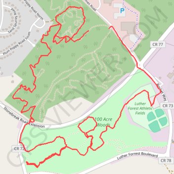
Name: 100 acre woods GPS track, route, trail
Start: Main Loop, Town of Malta, Saratoga County, New York, 12151, United States (42.96605 -73.76922)
End: Main Loop, Town of Malta, Saratoga County, New York, 12151, United States (42.96618 -73.76706)
Coordinates: 42.95518 -73.77746 42.96796 -73.76143
Other GPS tracks
Click on a GPS track to view route, its statistics and profile.
Montréal - New York
Canada > Québec > Agglomération de Montréal > Montréal
Distance: 637.3 Km • Elevation gain: 4,134 m • Maximum elevation: 301 m
Niagara - Albany
États-Unis d'Amérique > New York > Niagara County > City of Niagara Falls
Distance: 538.0 Km • Elevation gain: 2,411 m • Maximum elevation: 198 m