Le chemin Inca
Randonnée pédestre. En aller simple. #Randonnée
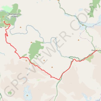
- Distance: 42.4 Km
- Elevation gain: 3,502 m
- Maximum elevation: 4,214 m
- Elevation loss: 3,753 m
- Minimum elevation: 2,408 m
Interactive map
GPS track profile
About this GPS track
Name: Le chemin Inca GPS track, route, trail
Start: Inca Trail, Patallacta, Ollantaytambo, Urubamba, Cusco, Pérou (-13.21412 -72.38096)
Coordinates: -13.26466 -72.54457 -13.16498 -72.38059