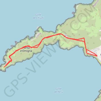
Cargese - Punta d'Omigna
Randonnée en aller-retour depuis Cargèse. #Randonnée
- Distance: 6.7 Km
- Elevation gain: 168 m
- Maximum elevation: 53 m
- Elevation loss: 168 m
- Minimum elevation: 5 m
Interactive map
GPS track profile
About this GPS track
Name: Cargese - Punta d'Omigna GPS track, route, trail
Coordinates: 42.14672 8.56013 42.15480 8.59064
Other GPS tracks
Click on a GPS track to view route, its statistics and profile.
1 LUCENA - MONTPELLIER
Distance: 2,964.4 Km • Elevation gain: 29,500 m • Maximum elevation: 1,048 m
1 LUCENA - MONTPELLIER
Espagne > Andalousie > Lucena
Distance: 2,964.4 Km • Elevation gain: 29,500 m • Maximum elevation: 1,048 m
Cargese - Gradella
France > Corse > Corse-du-Sud > Cargèse
Distance: 69.6 Km • Elevation gain: 3,428 m • Maximum elevation: 545 m
Cargèse - Tour génoise d'Omignia
France > Corse > Corse-du-Sud > Cargèse > Marchese
Randonnée depuis Cargèse. #Randonnée
Distance: 3.5 Km • Elevation gain: 85 m • Maximum elevation: 54 m