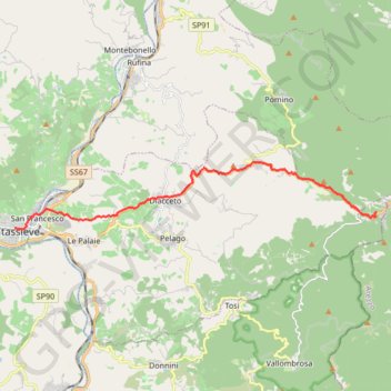
De Consuma à Pontassieve
Randonnée entre Consuma et Pontassieve. #Randonnée
- Distance: 15.7 Km
- Elevation gain: 65 m
- Maximum elevation: 1,030 m
- Elevation loss: 991 m
- Minimum elevation: 86 m
Interactive map
GPS track profile
About this GPS track
Name: De Consuma à Pontassieve GPS track, route, trail
Coordinates: 43.77441 11.43642 43.79543 11.59313
Other GPS tracks
Click on a GPS track to view route, its statistics and profile.
Tour d'Europe
France > Bretagne > Finistère > Concarneau > Landan Creis
Distance: 7,132.9 Km • Elevation gain: 44,603 m • Maximum elevation: 2,433 m
Eurovelo 6
France > Pays de la Loire > Loire-Atlantique > Saint-Brevin-les-Pins
Distance: 4,530.3 Km • Elevation gain: 18,043 m • Maximum elevation: 856 m
1 LUCENA - MONTPELLIER
Distance: 2,964.4 Km • Elevation gain: 29,500 m • Maximum elevation: 1,048 m
Percorso selezionato
Italie > Lombardie > Côme > Côme
Percorso calcolato con http://www.bicitalia.org/it/routing-gpx
Distance: 1,543.9 Km • Elevation gain: 17,951 m • Maximum elevation: 1,034 m
Tuscany-Trail-2019
Italie > Toscane > Massa > San Carlo
Distance: 548.4 Km • Elevation gain: 10,357 m • Maximum elevation: 803 m
1 LUCENA - MONTPELLIER
Espagne > Andalousie > Lucena
Distance: 2,964.4 Km • Elevation gain: 29,500 m • Maximum elevation: 1,048 m
De Giromagny à Sofia
France > Bourgogne-Franche-Comté > Territoire-de-Belfort > Giromagny
Distance: 1,875.9 Km • Elevation gain: 12,108 m • Maximum elevation: 1,054 m
Euro 6
France > Pays de la Loire > Loire-Atlantique > Saint-Brevin-les-Pins
Distance: 4,239.9 Km • Elevation gain: 15,869 m • Maximum elevation: 856 m
10 Gen 2024 11:25:46
Italy > Tuscany > Florence > Florence
Distance: 247.8 Km • Elevation gain: 5,023 m • Maximum elevation: 430 m
De Pontassieve à Florence
Italie > Toscane > Firenze > Pontassieve
Randonnée entre Pontassieve et Firenze. #Randonnée
Distance: 19.5 Km • Elevation gain: 113 m • Maximum elevation: 96 m
De Poppi à Consuma
Italie > Toscane > Arezzo > Ponte a Poppi
Randonnée depuis Poppi. #Randonnée
Distance: 20.6 Km • Elevation gain: 892 m • Maximum elevation: 1,062 m