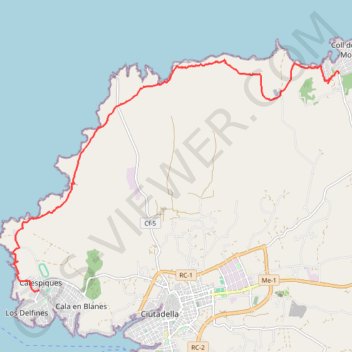
Cala Morell - Ciutadella
Randonnée depuis Ciutadella de Menorca. #Randonnée
- Distance: 14.3 Km
- Elevation gain: 327 m
- Maximum elevation: 108 m
- Elevation loss: 361 m
- Minimum elevation: 7 m
- Moving time: 3 h 4 m
- Moving speed: 4.7 Km/h
- Maximum speed: 7.2 Km/h
- Total time: 3 h 32 m
- Global speed: 4.0 Km/h
- Date: 17/07/14
Interactive map
GPS track profile
About this GPS track
Name: Cala Morell - Ciutadella GPS track, route, trail
Coordinates: 40.00500 3.79519 40.05363 3.88449
Other GPS tracks
Click on a GPS track to view route, its statistics and profile.
Southern section — European Divide Trail
France > Auvergne-Rhône-Alpes > Drôme > Valence
Distance: 2,423.8 Km • Elevation gain: 42,375 m • Maximum elevation: 2,005 m
1 LUCENA - MONTPELLIER
Distance: 2,964.4 Km • Elevation gain: 29,500 m • Maximum elevation: 1,048 m
1 LUCENA - MONTPELLIER
Espagne > Andalousie > Lucena
Distance: 2,964.4 Km • Elevation gain: 29,500 m • Maximum elevation: 1,048 m
Stage 26: Valence to Saint-Jean-de-Fos — European Divide Trail
France > Auvergne-Rhône-Alpes > Drôme > Valence
Distance: 2,423.8 Km • Elevation gain: 42,375 m • Maximum elevation: 2,005 m
PARCOURS-98km-IBP256-hiking
Espagne > Îles Baléares > Minorque > Port-Mahon > es Grau
Parcours créé avec gpstraces.net. Indice IBP de cette trace : 256
Distance: 97.3 Km • Elevation gain: 1,450 m • Maximum elevation: 216 m
Stage 26: Valence to Saint-Jean-de-Fos — European Divide Trail
France > Auvergne-Rhône-Alpes > Drôme > Valence
Distance: 1,629.8 Km • Elevation gain: 30,841 m • Maximum elevation: 2,005 m