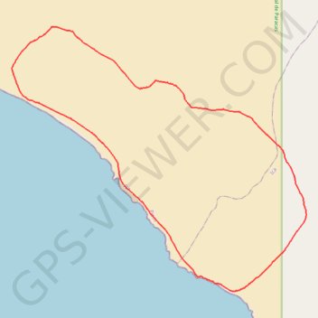
HDMS étape 1
- Distance: 30.5 Km
- Elevation gain: 865 m
- Maximum elevation: 690 m
- Elevation loss: 865 m
- Minimum elevation: 3 m
- Moving time: 4 h 26 m
- Moving speed: 6.9 Km/h
- Maximum speed: 11.4 Km/h
- Total time: 4 h 34 m
- Global speed: 6.7 Km/h
- Date: 02/12/19
Interactive map
GPS track profile
About this GPS track
Name: HDMS étape 1 GPS track, route, trail
Start: Paracas, Pisco, Ica, Pérou (-14.37358 -76.08542)
End: Paracas, Pisco, Ica, Pérou (-14.37368 -76.08524)
Coordinates: -14.43479 -76.09115 -14.35025 -75.99407
Other GPS tracks
Click on a GPS track to view route, its statistics and profile.
HMDS 3eme étape
Distance: 21.9 Km • Elevation gain: 502 m • Maximum elevation: 229 m
HDMS étape 2
Distance: 54.8 Km • Elevation gain: 1,231 m • Maximum elevation: 712 m