New
- Distance: 5.9 Km
- Elevation gain: 74 m
- Maximum elevation: 51 m
- Elevation loss: 89 m
- Minimum elevation: 11 m
Interactive map
GPS track profile
About this GPS track
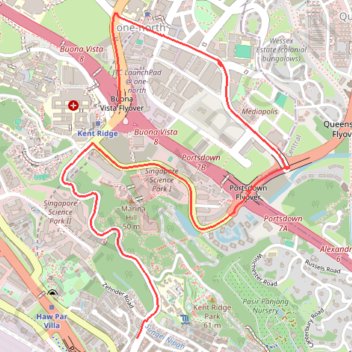
Name: New GPS track, route, trail
End: 21, South Buona Vista Road, Queenstown, Southwest, Singapore, 118161, Singapore (1.28088 103.78676)
Coordinates: 1.28088 103.78243 1.29956 103.79548
Other GPS tracks
Click on a GPS track to view route, its statistics and profile.
The Green Corridor - Singapore
Singapore > Northwest > Singapore
#Hike
Distance: 22.3 Km • Elevation gain: 167 m • Maximum elevation: 44 m
Directions from Duck Tour Ramp to Marina Boulevard, Singapore
Singapore > Central > Singapore
Distance: 105.3 Km • Elevation gain: 812 m • Maximum elevation: 51 m
Kualanamu International Airport to Jakarta, Indonesia
Indonésie > Sumatra du Nord > Deli Serdang > Beringin
Distance: 1,809.2 Km • Elevation gain: 10,977 m • Maximum elevation: 125 m