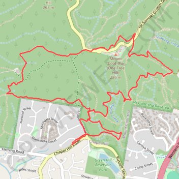
Brisbane Trail Run
Mount Coot-Tha MTB trails
- Distance: 7.9 Km
- Elevation gain: 273 m
- Maximum elevation: 224 m
- Elevation loss: 273 m
- Minimum elevation: 57 m
- Moving time: 1 h 10 m
- Moving speed: 6.7 Km/h
- Maximum speed: 14.0 Km/h
- Total time: 1 h 10 m
- Global speed: 6.7 Km/h
- Date: 01/04/24
Interactive map
GPS track profile
About this GPS track
Name: Brisbane Trail Run GPS track, route, trail
Start: 262, Chapel Hill Road, Chapel Hill, Brisbane City, Queensland, 4069, Australia (-27.49367 152.95413)
End: 258, Chapel Hill Road, Chapel Hill, Brisbane City, Queensland, 4069, Australia (-27.49389 152.95409)
Coordinates: -27.49389 152.94694 -27.48302 152.96511
Other GPS tracks
Click on a GPS track to view route, its statistics and profile.