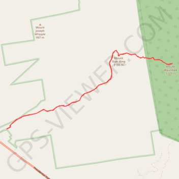
Mount Waumbek and Mount Starr King
Hike to Mount Waumbek and Mount Starr King via Starr King Trail and Kilkenny Ridge Trail in the White Mountain National Forest. #Hike #Mountain #Nature #Forest
- Distance: 10.8 Km
- Elevation gain: 819 m
- Maximum elevation: 1,208 m
- Elevation loss: 820 m
- Minimum elevation: 484 m
- Moving time: 3 h 5 m
- Moving speed: 3.5 Km/h
- Maximum speed: 5.5 Km/h
- Total time: 3 h 24 m
- Global speed: 3.2 Km/h
- Date: 29/08/23
Interactive map
GPS track profile
About this GPS track
Name: Mount Waumbek and Mount Starr King GPS track, route, trail
Start: Starr King Trail, Jefferson, Coös County, New Hampshire, 03583, United States (44.41850 -71.46678)
End: Starr King Trail, Jefferson, Coös County, New Hampshire, 03583, United States (44.41848 -71.46682)
Coordinates: 44.41848 -71.46682 44.43556 -71.41646
Other GPS tracks
Click on a GPS track to view route, its statistics and profile.