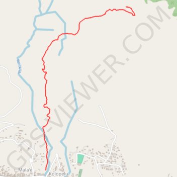
FUTUNA - accès col
- Distance: 3.8 Km
- Elevation gain: 350 m
- Maximum elevation: 348 m
- Elevation loss: 92 m
- Minimum elevation: 9 m
- Moving time: 1 h 13 m
- Moving speed: 3.1 Km/h
- Maximum speed: 5.3 Km/h
- Total time: 1 h 22 m
- Global speed: 2.7 Km/h
- Date: 28/12/13
Interactive map
GPS track profile
About this GPS track
Name: FUTUNA - accès col GPS track, route, trail
Start: Kolopelu, Alo, Wallis-et-Futuna, 98610, France (-14.30849 -178.11975)
End: Olu, Alo, Wallis-et-Futuna, 98610, France (-14.28822 -178.10951)
Coordinates: -14.30849 -178.12021 -14.28822 -178.10837
Other GPS tracks
Click on a GPS track to view route, its statistics and profile.
FUTUNA - tour de l'île
France > Wallis-et-Futuna > Sigave > Leava
Distance: 32.6 Km • Elevation gain: 585 m • Maximum elevation: 127 m
FUTUNA - balade Malaé
France > Wallis-et-Futuna > Alo > Mala'e
Distance: 0.8 Km • Elevation gain: 20 m • Maximum elevation: 168 m