Trail Planner Map
- Distance: 4.3 Km
- Elevation gain: 126 m
- Maximum elevation: 1,328 m
- Elevation loss: 126 m
- Minimum elevation: 1,232 m
Interactive map
GPS track profile
About this GPS track
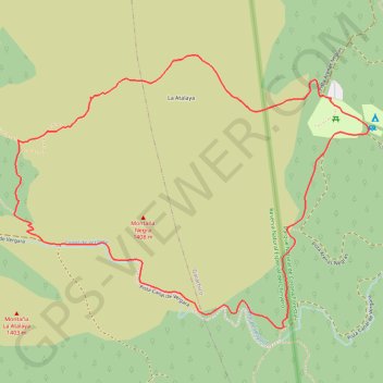
Name: Trail Planner Map GPS track, route, trail
Coordinates: 28.31248 -16.76929 28.32153 -16.75595
Other GPS tracks
Click on a GPS track to view route, its statistics and profile.
Trail Planner Map
Distance: 6.0 Km • Elevation gain: 177 m • Maximum elevation: 1,317 m