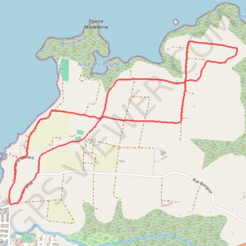
🚶 Trace Champs de canne à sucre de Birmingham
🌍 Tag :
#FranceTourisme #OfficeTourisme #RandonnéesFrance
🚶 Par - Bons plans en France Google Maps :
https://www.google.com/maps/d/embed?mid=1VJ6s4u13Cn0OaTEAOgdmNOh9tNxCCnno
- Distance: 6.5 Km
- Elevation gain: 58 m
- Maximum elevation: 28 m
- Elevation loss: 58 m
- Minimum elevation: 4 m
- Moving time: 1 h 44 m
- Moving speed: 3.7 Km/h
- Maximum speed: 4.9 Km/h
- Total time: 1 h 59 m
- Global speed: 3.3 Km/h
- Date: 29/05/20
Interactive map
GPS track profile
About this GPS track
Name: 🚶 Trace Champs de canne à sucre de Birmingham GPS track, route, trail
Coordinates: 16.26984 -61.58337 16.28359 -61.56339