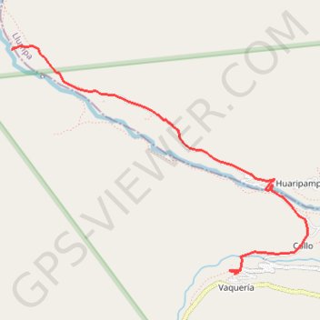
Santa Cruz 4/4
Randonnée pédestre. En aller simple. #Randonnée
- Distance: 5.8 Km
- Elevation gain: 256 m
- Maximum elevation: 3,689 m
- Elevation loss: 325 m
- Minimum elevation: 3,416 m
- Moving time: 1 h 53 m
- Moving speed: 3.1 Km/h
- Maximum speed: 5.8 Km/h
- Total time: 2 h 48 s
- Global speed: 2.9 Km/h
- Date: 10/09/12
Interactive map
GPS track profile
About this GPS track
Name: Santa Cruz 4/4 GPS track, route, trail
Start: AN-106, Vaquería, Yanama, Yungay, Ancash, Pérou (-8.98708 -77.55312)
End: Vaquería, Yanama, Yungay, Ancash, Pérou (-9.00937 -77.53112)
Coordinates: -9.00937 -77.55334 -8.98687 -77.52380
Other GPS tracks
Click on a GPS track to view route, its statistics and profile.
Santa Cruz 3/4
Pérou > Ancash > Santa Cruz
Randonnée pédestre. En aller simple. #Randonnée
Distance: 15.4 Km • Elevation gain: 732 m • Maximum elevation: 4,764 m