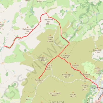
Church Stretton to Bridges
- Distance: 15.4 Km
- Elevation gain: 410 m
- Maximum elevation: 512 m
- Elevation loss: 354 m
- Minimum elevation: 196 m
- Moving time: 4 h 31 m
- Moving speed: 3.4 Km/h
- Maximum speed: 5.7 Km/h
- Total time: 5 h 36 m
- Global speed: 2.7 Km/h
- Date: 18/04/24
Interactive map
GPS track profile
About this GPS track
Name: Church Stretton to Bridges GPS track, route, trail
End: Bridges, Ratlinghope, Shropshire, England, SY5 0ST, United Kingdom (52.56254 -2.89640)
Coordinates: 52.53776 -2.89655 52.58156 -2.80779
Other GPS tracks
Click on a GPS track to view route, its statistics and profile.
Bridges to Bishops Castle
United Kingdom > England > Shropshire > Bridges
Distance: 18.9 Km • Elevation gain: 548 m • Maximum elevation: 527 m
TT22 J9 M7/06 : Heysham Port à Aberystwyth
Royaume-Uni > Angleterre > Lancashire > Lancaster > Morecambe
Distance: 347.4 Km • Elevation gain: 4,043 m • Maximum elevation: 419 m