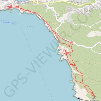
Capu Pertusato - Bonifacio
Interactive map
GPS track profile
About this GPS track
Name: Capu Pertusato - Bonifacio GPS track, route, trail
Coordinates: 41.36739 9.15869 41.38770 9.18491
Other GPS tracks
Click on a GPS track to view route, its statistics and profile.
1 LUCENA - MONTPELLIER
Distance: 2,964.4 Km • Elevation gain: 29,500 m • Maximum elevation: 1,048 m
Sentier de Campu Romanellu & Pertusatu
France > Corse > Corse-du-Sud > Bonifacio > Piantarella
Randonnée en aller-retour depuis Bonifacio. #Randonnée
Distance: 11.2 Km • Elevation gain: 514 m • Maximum elevation: 104 m
1 LUCENA - MONTPELLIER
Espagne > Andalousie > Lucena
Distance: 2,964.4 Km • Elevation gain: 29,500 m • Maximum elevation: 1,048 m
Percorso selezionato
Italie > Lombardie > Côme > Côme
Percorso calcolato con http://www.bicitalia.org/it/routing-gpx
Distance: 1,543.9 Km • Elevation gain: 17,951 m • Maximum elevation: 1,034 m
La boucle du Capo Pertusato à Bonifacio
France > Corse > Corse-du-Sud > Bonifacio > Piantarella
Distance: 5.3 Km • Elevation gain: 202 m • Maximum elevation: 96 m
Ajaccio - Bastia par le sud
France > Corse > Corse-du-Sud > Ajaccio
Vélo. En aller simple entre Ajaccio et Bastia. #Vélo
Distance: 337.2 Km • Elevation gain: 4,747 m • Maximum elevation: 556 m
Rando Corse Bonifacio - Cap Pertusato
France > Corse > Corse-du-Sud > Bonifacio
Randonnée pédestre. Depuis Bonifacio. #Randonnée
Distance: 8.3 Km • Elevation gain: 326 m • Maximum elevation: 102 m
Sentier de Campu Romanellu & Pertusatu
France > Corse > Corse-du-Sud > Bonifacio > Piantarella
Distance: 11.0 Km • Elevation gain: 486 m • Maximum elevation: 104 m
TG6ak
France > Corse > Haute-Corse > Bastia
tour de corse vélo de voyage trace en préparation
Distance: 811.0 Km • Elevation gain: 22,311 m • Maximum elevation: 1,478 m
La boucle du Capo Pertusato à Bonifacio
France > Corse > Corse-du-Sud > Bonifacio > Piantarella
Distance: 5.3 Km • Elevation gain: 199 m • Maximum elevation: 96 m
Corse, Bonifacio, Capo Pertusato
France > Corse > Corse-du-Sud > Bonifacio
Randonnée pédestre. Depuis Bonifacio. #Randonnée
Distance: 6.6 Km • Elevation gain: 268 m • Maximum elevation: 102 m