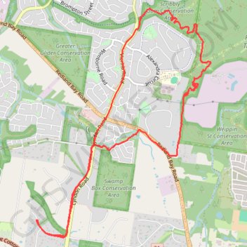
Weippin Street, Redlands and Scribbly Gum Loop
Loop hike /run via Weippin Street Conservation Area, Redlands Track Park and Scribbly Gum Conservation Area. #Hike #Run #Loop #City #Nature #Forest #Park
- Distance: 12.1 Km
- Elevation gain: 162 m
- Maximum elevation: 57 m
- Elevation loss: 162 m
- Minimum elevation: 24 m
- Moving time: 1 h 12 m
- Moving speed: 10.0 Km/h
- Maximum speed: 17.4 Km/h
- Total time: 1 h 20 m
- Global speed: 9.0 Km/h
- Date: 28/01/24
Interactive map
GPS track profile
About this GPS track
Name: Weippin Street, Redlands and Scribbly Gum Loop GPS track, route, trail
Coordinates: -27.56362 153.21188 -27.53345 153.23785
Other GPS tracks
Click on a GPS track to view route, its statistics and profile.