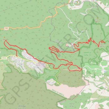
Single Nahal Bustan
נחל בוסטן - רון
- Distance: 29.1 Km
- Elevation gain: 625 m
- Maximum elevation: 488 m
- Elevation loss: 625 m
- Minimum elevation: 123 m
- Moving time: 2 h 8 m
- Moving speed: 13.6 Km/h
- Maximum speed: 32.5 Km/h
- Total time: 2 h 41 m
- Global speed: 10.8 Km/h
Interactive map
GPS track profile
About this GPS track
Name: Single Nahal Bustan GPS track, route, trail
Coordinates: 32.69595 34.97586 32.71033 35.02760
Topography: Hof HaCarmel Regional Council topographic map, elevation, terrain
Other GPS tracks
Click on a GPS track to view its route, statistics and profile.
עין הוד
Israel > Haifa District > Hof HaCarmel Regional Council
Morning Ride
Distance: 28.6 Km • Elevation gain: 790 m • Maximum elevation: 487 m
Home78Rec
Israel > Haifa District > Nesher
Distance: 78.4 Km • Elevation gain: 1,479 m • Maximum elevation: 461 m