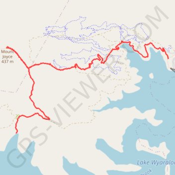
Mount Joyce
Hike / run to Mount Joyce from the Lake Wyaralong. #Hike #Run #Lake #Mountain #Forest #Nature
- Distance: 9.0 Km
- Elevation gain: 427 m
- Maximum elevation: 446 m
- Elevation loss: 417 m
- Minimum elevation: 68 m
- Moving time: 1 h 35 m
- Moving speed: 5.7 Km/h
- Maximum speed: 12.8 Km/h
- Total time: 1 h 41 m
- Global speed: 5.3 Km/h
- Date: 17/02/24
Interactive map
GPS track profile
About this GPS track
Name: Mount Joyce GPS track, route, trail
End: Service Road, Wyaralong, Scenic Rim Regional, Queensland, Australia (-27.90565 152.87998)
Coordinates: -27.91921 152.84659 -27.90242 152.87998
Other GPS tracks
Click on a GPS track to view route, its statistics and profile.