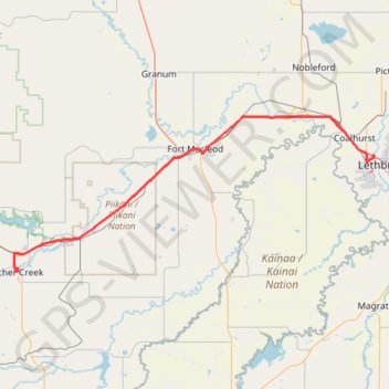
Pincher Creek - Lethbridge
#Bike #PincherCreek #Lethbridge
- Distance: 101.5 Km
- Elevation gain: 228 m
- Maximum elevation: 1,146 m
- Elevation loss: 525 m
- Minimum elevation: 825 m
Interactive map
GPS track profile
About this GPS track
Name: Pincher Creek - Lethbridge GPS track, route, trail
Start: Cowboy Trail, Pincher Creek, Division No. 3, Alberta, T0K 1W0, Canada (49.49290 -113.93645)
End: Lethbridge KOA, Bridge Drive W, Lethbridge, Alberta, T1J 4B4, Canada (49.71109 -112.87283)
Coordinates: 49.48559 -113.94801 49.78561 -112.86866
Other GPS tracks
Click on a GPS track to view route, its statistics and profile.
Lethbridge - Bow Island
Canada > Alberta > Lethbridge
Distance: 116.9 Km • Elevation gain: 273 m • Maximum elevation: 924 m
Blairmore - Pincher Creek
Canada > Alberta > Division No. 15 > Crowsnest Pass
#Bike #Blairmore #PincherCreek
Distance: 47.4 Km • Elevation gain: 259 m • Maximum elevation: 1,304 m
Départ - Alberta
Canada > Colombie-Britannique > District régional du Grand Vancouver > Vancouver
Distance: 2,596.8 Km • Elevation gain: 17,360 m • Maximum elevation: 2,042 m