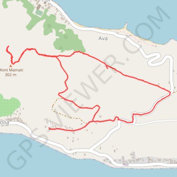
FUTUNA - Mont MAMATI
- Distance: 6.4 Km
- Elevation gain: 291 m
- Maximum elevation: 301 m
- Elevation loss: 291 m
- Minimum elevation: 80 m
- Moving time: 1 h 36 m
- Moving speed: 4.0 Km/h
- Maximum speed: 20.6 Km/h
- Total time: 1 h 46 m
- Global speed: 3.6 Km/h
- Date: 17/07/14
Interactive map
GPS track profile
About this GPS track
Name: FUTUNA - Mont MAMATI GPS track, route, trail
Start: Kolia, Alo, Wallis-et-Futuna, 98610, France (-14.30739 -178.08686)
End: Kolia, Alo, Wallis-et-Futuna, 98610, France (-14.30806 -178.09168)
Coordinates: -14.30839 -178.09629 -14.29950 -178.07845
Other GPS tracks
Click on a GPS track to view route, its statistics and profile.
FUTUNA - tour de l'île
France > Wallis-et-Futuna > Sigave > Leava
Distance: 32.6 Km • Elevation gain: 585 m • Maximum elevation: 127 m