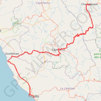
Chachapoyas-Trujillo
Vélo. Entre Chachapoyas et Trujillo. #Vélo
- Distance: 649.1 Km
- Elevation gain: 12,485 m
- Maximum elevation: 3,750 m
- Elevation loss: 14,805 m
- Minimum elevation: 2 m
- Moving time: 2 d 4 h
- Moving speed: 12.5 Km/h
- Maximum speed: 53.5 Km/h
- Total time: 12 d 7 h
- Global speed: 2.2 Km/h
- Date: 17/03/15
Interactive map
GPS track profile
About this GPS track
Name: Chachapoyas-Trujillo GPS track, route, trail
Start: Jirón Dos de Mayo, Pedro Castro, Chachapoyas, Amazonas, 01001, Pérou (-6.23162 -77.87099)
Coordinates: -8.13770 -79.55860 -6.22485 -77.79611
Other GPS tracks
Click on a GPS track to view route, its statistics and profile.
La balsa-Chachapoyas
Équateur > Zamora Chinchipe > Chinchipe > La Balsa
Vélo. #Vélo
Distance: 335.2 Km • Elevation gain: 9,491 m • Maximum elevation: 2,347 m