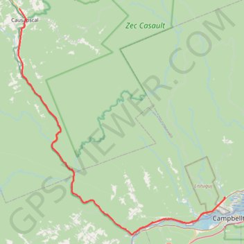
Causapscal - Campbellton
#Bike #Causapscal #Campbellton
- Distance: 79.6 Km
- Elevation gain: 680 m
- Maximum elevation: 169 m
- Elevation loss: 842 m
- Minimum elevation: 3 m
Interactive map
GPS track profile
About this GPS track
Name: Causapscal - Campbellton GPS track, route, trail
Coordinates: 47.97466 -67.24362 48.37248 -66.69621
Other GPS tracks
Click on a GPS track to view route, its statistics and profile.
Campbellton - Bathurst
Canada > Quebec > Avignon > Pointe-à-la-Croix > Cross Point Station
Ristigouche River. Gulf of Saint Lawrence. #Bike #Campbellton #Bathurst #Ristigouche #SaintLawrence
Distance: 119.2 Km • Elevation gain: 668 m • Maximum elevation: 69 m
New Richmond - Campbellton
Canada > Quebec > Bonaventure (MRC) > New Richmond
Ristigouche River. Gulf of Saint Lawrence. #Bike #SaintLawrence
Distance: 74.6 Km • Elevation gain: 475 m • Maximum elevation: 58 m
Sayabec - Causapscal
Canada > Quebec > La Matapédia > Sayabec
Lake Matapédia. #Bike #Sayabec #Causapscal #Matapédia
Distance: 52.6 Km • Elevation gain: 345 m • Maximum elevation: 266 m