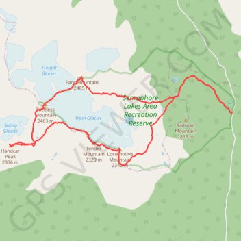
Train-Glacier-5-Peaks-Loop-with-a-Handcar-Mnt-Detour
- Distance: 18.9 Km
- Elevation gain: 2,147 m
- Maximum elevation: 2,476 m
- Elevation loss: 2,148 m
- Minimum elevation: 1,347 m
Interactive map
GPS track profile
About this GPS track
Name: Train-Glacier-5-Peaks-Loop-with-a-Handcar-Mnt-Detour GPS track, route, trail
Coordinates: 50.57870 -123.09858 50.59927 -123.01769
Topography: Area C (Pemberton Valley/Mount Currie/D'Arcy) topographic map
Other GPS tracks
Click on a GPS track to view route, its statistics and profile.