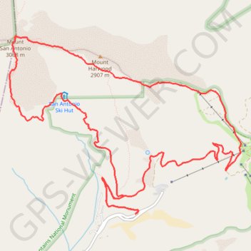
Mount San Antonio Loop via Mount Baldy
Interactive map
GPS track profile
About this GPS track
Name: Mount San Antonio Loop via Mount Baldy GPS track, route, trail
Start: 2, Mount Baldy Road, San Bernardino County, California, 91759, United States (34.26590 -117.62746)
End: 2, Mount Baldy Road, San Bernardino County, California, 91759, United States (34.26590 -117.62746)
Coordinates: 34.26590 -117.64731 34.28905 -117.61075
Other GPS tracks
Click on a GPS track to view route, its statistics and profile.
Three T's Trail
United States > California > San Bernardino County
Loop hike to Timber Mountain, Telegraph Peak and Thunder Mountain along the Three T's Trail via Icehouse Canyon Trail, Icehouse Saddle, Mount Baldy Notch and ount Baldy Road in Angeles National Forest. #Hike #Loop #Mountain #Nature #Forest #Angeles
Distance: 24.4 Km • Elevation gain: 1,669 m • Maximum elevation: 2,726 m