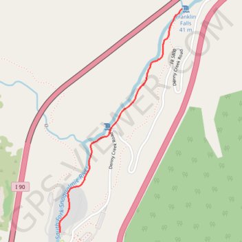
Franklin Falls via Denny Camp Falls
Interactive map
GPS track profile
About this GPS track
Name: Franklin Falls via Denny Camp Falls GPS track, route, trail
Start: Franklin Falls Trail #1036, King County, Washington, 98068, United States (47.41310 -121.44277)
End: Franklin Falls Trail #1036, King County, Washington, 98068, United States (47.41310 -121.44277)
Coordinates: 47.41310 -121.44280 47.42496 -121.43319
Other GPS tracks
Click on a GPS track to view route, its statistics and profile.
Northern part of the Pacific Crest Trail (PCT)
United States > Oregon > Klamath County
Hike on the Pacific Crest National Scenic Trail from Crater Lake to Canada Border through Oregon and Washington along the Sierra Nevada and Cascade mountain ranges. #Hike #Mountain #SierraNevada #Cascade #Nature #Forest #Park #PCT
Distance: 1,198.3 Km • Elevation gain: 44,308 m • Maximum elevation: 2,307 m