Peekaboo Loop from Bryce Point
Interactive map
GPS track profile
About this GPS track
Name: Peekaboo Loop from Bryce Point GPS track, route, trail
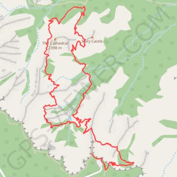
Start: Rim Trail, Garfield County, Utah, United States (37.60483 -112.15750)
End: Rim Trail, Garfield County, Utah, United States (37.60483 -112.15750)
Coordinates: 37.60336 -112.16285 37.61761 -112.15287
Other GPS tracks
Click on a GPS track to view route, its statistics and profile.
Figure-8 Combination Loop (Bryce Canyon)
United States > Utah > Garfield County
Loop hike in the Bryce Canyon National Park from Sunset Point via Rim Trail, Sunrise Point, Queen's Garden Trail, Tropic Trail, Peekaboo Loop Trail, Peek a Boo Arch, Hindu Temples, The Cathedral, Navajo Loop Trail, Two Bridges and Thor's Hammer. #Hike #Loop #Canyon #Nature #Mountain #Rock #Forest #Park
Distance: 10.3 Km • Elevation gain: 500 m • Maximum elevation: 2,431 m
Peekaboo Loop from Bryce Point
États-Unis d'Amérique > Utah > Garfield County
Distance: 8.4 Km • Elevation gain: 514 m • Maximum elevation: 2,535 m