Purple Mountain
Interactive map
GPS track profile
About this GPS track
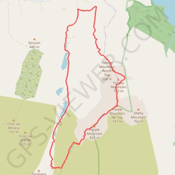
Name: Purple Mountain GPS track, route, trail
Start: Dunloe ED, Kenmare Municipal District, County Kerry, Munster, V93 E029, Ireland (52.04077 -9.63141)
Coordinates: 51.99460 -9.64484 52.04490 -9.60701
Other GPS tracks
Click on a GPS track to view route, its statistics and profile.
The-kerry-way-entire-trail-walking-route-map-and-guide-kerry-ireland
Irlande > Comté de Kerry > Killarney
Distance: 201.2 Km • Elevation gain: 5,003 m • Maximum elevation: 380 m
Purple Mountain
Distance: 15.4 Km • Elevation gain: 861 m • Maximum elevation: 818 m
Trace IRELAND
Distance: 1,506.7 Km • Elevation gain: 13,359 m • Maximum elevation: 524 m
RT5-1 Rosslare - Kinsale
Distance: 2,860.3 Km • Elevation gain: 27,381 m • Maximum elevation: 420 m
RT5-1 Rosslare - Kinsale
Distance: 3,867.1 Km • Elevation gain: 36,115 m • Maximum elevation: 524 m
RT5-1 Rosslare - Kinsale
Distance: 1,353.5 Km • Elevation gain: 15,245 m • Maximum elevation: 420 m