Import a GPX file

Boucle a partir de Houston Station

  • Distance: 5.5 Km
  • Elevation gain: 81 m
  • Maximum elevation: 41 m
  • Elevation loss: 85 m
  • Minimum elevation: 7 m

Interactive map

GPS track profile

About this GPS track
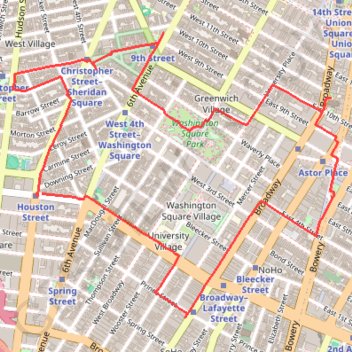
Other GPS tracks

Click on a GPS track to view route, its statistics and profile.

Marathon de New York City

États-Unis d'Amérique > New York > New York

Course à pied / trail. En aller simple. #Course #Trail #Marathon #NewYork

Distance: 43.3 Km • Elevation gain: 407 m • Maximum elevation: 45 m

New York City Marathon

United States > New York > New York

Marathon from Staten Island to Central Park. #Marathon #Run #City #Sea #River #Park #Atlantic #Ocean

Distance: 43.3 Km • Elevation gain: 389 m • Maximum elevation: 45 m

Marathon de New York City

États-Unis d'Amérique > New York > New York

#Course #Marathon #NewYork

Distance: 43.3 Km • Elevation gain: 386 m • Maximum elevation: 45 m

Walk in Manhattan

United States > New York > New York County > New York

Hike through famous places of Manhattan from Central Park to Battery Park. #Walk #Hike #Manhattan #NewYork #City #Park #Sea

Distance: 25.7 Km • Elevation gain: 514 m • Maximum elevation: 63 m

Traversée New York

États-Unis d'Amérique > New York > New York

Vélo. En aller simple. #Vélo

Distance: 43.1 Km • Elevation gain: 378 m • Maximum elevation: 43 m