עין הוד
Morning Ride
- Distance: 28.6 Km
- Elevation gain: 790 m
- Maximum elevation: 487 m
- Elevation loss: 790 m
- Minimum elevation: 24 m
- Moving time: 3 h 13 m
- Moving speed: 8.9 Km/h
- Maximum speed: 45.0 Km/h
- Total time: 4 h 47 m
- Global speed: 6.0 Km/h
- Date: 26/04/24
Interactive map
GPS track profile
About this GPS track
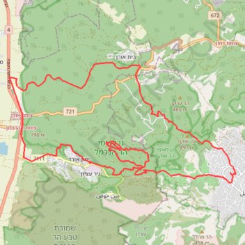
Name: עין הוד GPS track, route, trail
Coordinates: 32.69483 34.96637 32.72895 35.04240
Topography: Hof HaCarmel Regional Council topographic map
Other GPS tracks
Click on a GPS track to view route, its statistics and profile.
Home78Rec
Israel > Haifa District > Nesher
Distance: 78.4 Km • Elevation gain: 1,479 m • Maximum elevation: 461 m