צופר- פוביצר
- Distance: 42.8 Km
- Elevation gain: 887 m
- Maximum elevation: 359 m
- Elevation loss: 892 m
- Minimum elevation: 10 m
Interactive map
GPS track profile
About this GPS track
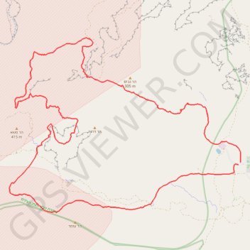
Name: צופר- פוביצר GPS track, route, trail
Start: Zofar, Arava Tichona Regional Council, Beersheba Subdistrict, Israel (30.56052 35.17059)
End: Zofar, Arava Tichona Regional Council, Beersheba Subdistrict, Israel (30.56129 35.17170)
Coordinates: 30.54176 35.06645 30.61027 35.17176
Topography: Arava Tichona Regional Council topographic map, elevation, terrain