סובב רמות ונבי סמואל
Exploration trail run went beyond expectations
- Distance: 18.6 Km
- Elevation gain: 515 m
- Maximum elevation: 886 m
- Elevation loss: 519 m
- Minimum elevation: 568 m
- Moving time: 2 h 48 m
- Moving speed: 6.6 Km/h
- Maximum speed: 36.0 Km/h
- Total time: 3 h 12 m
- Global speed: 5.8 Km/h
Interactive map
GPS track profile
About this GPS track
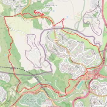
Name: סובב רמות ונבי סמואל GPS track, route, trail
Start: Ramot Bet, Jerusalem, Jerusalem Subdistrict, Jerusalem District, 9546522, Israel (31.80112 35.17249)
Coordinates: 31.79915 35.16521 31.83382 35.21162
Topography: Jerusalem topographic map, elevation, terrain
Other GPS tracks
Click on a GPS track to view its route, statistics and profile.
North West Jerusalem trail running
Israel > Jerusalem District > Jerusalem
Distance: 22.9 Km • Elevation gain: 632 m • Maximum elevation: 886 m
רומאים צרפתיים
Israel > Jerusalem District > Jerusalem
לאחרונה הריצות מתקיימות במקומות שאין ממש מסלולים מסומנים ולאחריהן נוספים הממסלולים. כזו גם הריצה הזו.
Distance: 21.3 Km • Elevation gain: 622 m • Maximum elevation: 811 m